The Amazon Rainforest: The World's Largest Rainforest
The Amazon River Basin is home to the largest
rainforest on Earth. The basin -- roughly the size of the forty-eight
contiguous United States -- covers some 40 percent of the South American
continent and includes parts of eight South American countries: Brazil, Bolivia, Peru, Ecuador, Colombia, Venezuela, Guyana, and Suriname, as well as French Guiana, a department of France.

Reflecting environmental conditions as well as past human influence,
the Amazon is made up of a mosaic of ecosystems and vegetation types
including rainforests, seasonal forests, deciduous forests, flooded forests, and savannas.
The basin is drained by the Amazon River, the world's largest river in
terms of discharge, and the second longest river in the world after the
Nile. The river is made up of over 1,100 tributaries, 17 of which are
longer than 1000 miles, and two of which (the Negro and the Madeira) are
larger, in terms of volume, than the Congo (formerly the Zaire) river.
The river system is the lifeline of the forest and its history plays an
important part in the development of its rainforests.

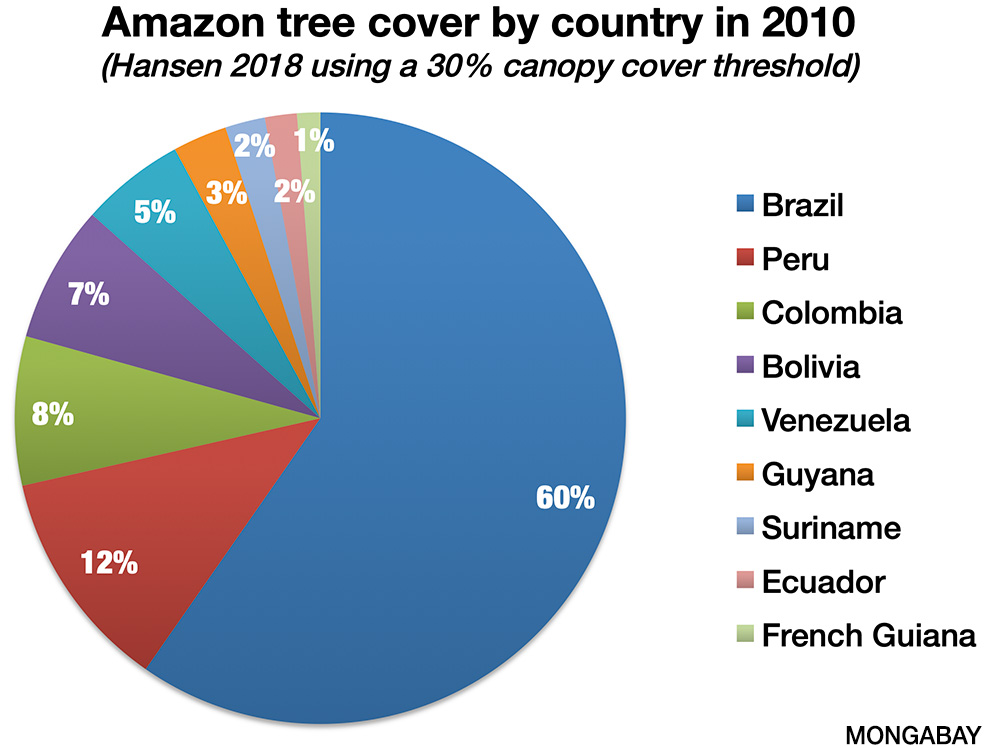
| Country | Tree cover extent, 2010 30% tree cover definition | Tree cover loss, 2010-2017 hectares | Tree cover loss as percentage of 2010 cover |
|---|---|---|---|
| Brazil | 320,902,659 | 17,784,762 | 5.5% |
| Bolivia | 39,035,889 | 2,269,636 | 5.8% |
| Peru | 63,290,191 | 1,654,462 | 2.6% |
| Colombia | 42,332,155 | 863,678 | 2.0% |
| Venezuela | 29,664,713 | 273,739 | 0.9% |
| Ecuador | 9,073,694 | 213,491 | 2.4% |
| Guyana | 15,432,968 | 109,875 | 0.7% |
| Suriname | 11,338,148 | 103,967 | 0.9% |
| French Guiana | 6,607,846 | 35,990 | 0.5% |
| Grand Total | 537,678,393 | 23,309,605 | 4.3% |
HISTORY OF THE AMAZON RAINFOREST
At one time Amazon River flowed westward,
perhaps as part of a proto-Congo (Zaire) river system from the interior
of present day Africa when the continents were joined as part of
Gondwana. Fifteen million years ago, the Andes were formed by the
collision of the South American plate with the Nazca plate. The rise of
the Andes and the linkage of the Brazilian and Guyana bedrock shields,
blocked the river and caused the Amazon to become a vast inland sea.
Gradually this inland sea became a massive swampy, freshwater lake and
the marine inhabitants adapted to life in freshwater. For example, over
20 species of stingray, most closely related to those found in the Pacific Ocean, can be found today in the freshwaters of the Amazon.
About ten million years ago, waters worked through
the sandstone to the west and the Amazon began to flow eastward. At this
time the Amazon rainforest was born. During the Ice Age, sea levels
dropped and the great Amazon lake rapidly drained and became a river.
Three million years later, the ocean level receded enough to expose the
Central American isthmus and allow mass migration of mammal species between the Americas.
The Ice Ages caused tropical rainforest around the world to retreat. Although debated,
it is believed that much of the Amazon reverted to savanna and montane
forest (see chapter 3-Ice Ages and Glaciation). Savanna divided patches
of rainforest into "islands" and separated existing species for periods
long enough to allow genetic differentiation (a similar rainforest
retreat took place in Africa. Delta core samples suggest that even the
mighty Congo watershed was void of rainforest
at this time). When the ice ages ended, the forest was again joined and
the species that were once one had diverged significantly enough to be
constitute designation as separate species, adding to the tremendous
diversity of the region. About 6000 years ago, sea levels rose about 130
meters, once again causing the river to be inundated like a long, giant
freshwater lake.
The world's largest rainforests [more]
1. Amazon Basin, South America 2. Congo Basin, Africa 3. Indonesian Archipelago, Southeast Asia
How large is the Amazon rainforest?
The extent of the Amazon depends on the definition.
The the Amazon River drains about 6.915 million sq km (2.722 sq mi), or
roughly 40 percent of South America, but generally areas outside the
basin are included when people speak about "the Amazon." The
biogeographic Amazon ranges from 7.76-8.24 million sq km (3-3.2 million
sq mi), of which just over 80 percent is forested. For comparison, the
land area of the United States (including Alaska and Hawaii) is
9,629,091 square kilometers (3,717,811 sq km).
Nearly two-thirds of the Amazon lies in Brazil.
|
THE AMAZON RIVER TODAY
Today the Amazon River is the most voluminous river
on Earth, eleven times the volume of the Mississippi, and drains an area
equivalent in size to the United States. During the high water season,
the river's mouth may be 300 miles wide and every day up to 500 billion
cubic feet of water (5,787,037 cubic feet/sec) flow into the Atlantic.
For reference, the Amazon's daily freshwater discharge into the Atlantic
is enough to supply New York City's freshwater needs for nine years.
The force of the current -- from sheer water volume alone -- causes
Amazon River water to continue flowing 125 miles out to sea before
mixing with Atlantic salt water. Early sailors could drink freshwater
out of the ocean before sighting the South American continent.
The river current carries tons of suspended sediment
all the way from the Andes and gives the river a characteristic muddy
whitewater appearance. It is calculated that 106 million cubic feet of
suspended sediment are swept into the ocean each day. The result from
the silt deposited at the mouth of the Amazon is Majaro island, a river
island about the size of Switzerland.
THE AMAZON RAINFOREST
While the Amazon Basin is home to the world's largest
tropical rainforest, the region consists of a number of ecosystems
ranging from natural savanna to swamps. Even the rainforest itself is
highly variable, tree diversity and structure varying depending on soil
type, history, drainage, elevation, and other factors. This is discussed
at greater length in the rainforest ecology section.
THE CHANGING AMAZON RAINFOREST
The Amazon has a long history of human settlement,
but in recent decades the pace of change has accelerated due to an
increase in human population, the introduction of mechanized
agriculture, and integration of the Amazon region into the global
economy. Vast quantities of commodities produced in the Amazon — cattle
beef and leather, timber, soy, oil and gas, and minerals, to name a few —
are exported today to China, Europe, the U.S., and other countries.
This shift has had substantial impacts on the Amazon.
This transition from a remote backwater to a cog in
the global economy has resulted in large-scale deforestation and forest
degradation in the Amazon — more than 1.4 million hectares of forest
have been cleared since the 1970s. An even larger area has been affected
by selective logging and forest fires.
Conversion for cattle grazing
is the biggest single direct driver of deforestation. In Brazil, more
than 60 percent of cleared land ends up as pasture, most of which has
low productivity, supporting less than one head per hectare. Across much
of the Amazon, the primary objective for cattle ranching is to
establish land claims, rather than produce beef or leather. But
market-oriented cattle production has nonetheless expanded rapidly
during the past decade.
Industrial agricultural production,
especially soy farms, has also been an important driver of
deforestation since the early 1990s. However since 2006 the Brazil soy
industry has had a moratorium on new forest clearing for soy. The
moratorium was a direct result of a Greenpeace campaign.
Mining, subsistence agriculture, dams, urban
expansion, agricultural fires, and timber plantations also result in
significant forest loss in the Amazon. Logging
is the primary driver of forest disturbance and studies have shown that
logged-over forests — even when selectively harvested — have a much
higher likelihood of eventual deforestation. Logging roads grant access to farmers and ranchers to previous inaccessible forest areas.
Deforestation isn't the only reason the Amazon is changing. Global climate change is having major impacts
on the Amazon rainforest. Higher temperatures in the tropical Atlantic
reduce rainfall across large extents of the Amazon, causing drought and
increasing the susceptibility of the rainforest to fire. Computer models
suggest that if current rates of warming continue, much of the Amazon
could transition from rainforest to savanna, especially in the southern
parts of the region. Such a shift could have dramatic economic and
ecological impacts, including affecting rainfall that currently feeds
regions that generate 70 percent of South America's GDP and triggering
enormous carbon emissions from forest die-off. These emissions could
further worsen climate change.

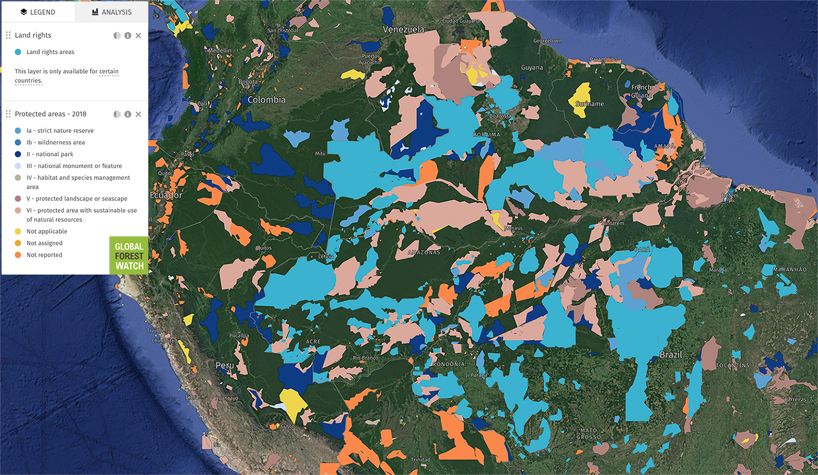
PROTECTING THE AMAZON RAINFOREST
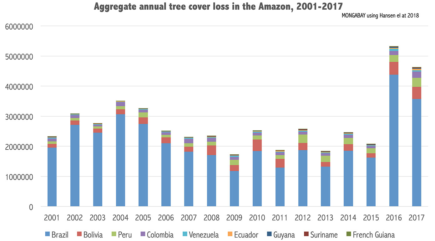
While destruction of the Amazon rainforest is
ongoing, the overall rate of deforestation rate in the region is
slowing, mostly due to to the sharp drop in forest clearing in Brazil
since 2004.
Brazil's declining deforestation rate has been
attributed to several factors, some of which it controls, some of which
it doesn't. Since 2000 Brazil has established the world's largest
network of protected areas, the majority of which are located in the
Amazon region. Since 2004 the government has also had a deforestation
reduction program in place. This includes improved law enforcement,
satellite monitoring, and financial incentives for respecting
environmental laws. Furthermore, the private sector — especially the
soy, logging, and cattle industries — are increasingly responsive to
consumer demand for less-damaging commodities. Finally the Brazilian
Amazon has been the site of a number of innovative and ambitious
conservation experiments, ranging from jurisdictional commodity
certification to indigenous led Reducing Emissions from Deforestation
and Degradation (REDD+) projects to Norway's billion dollar
performance-based payment for cutting deforestation.

AMAZON RAINFOREST NEWS
As habitat degradation threatens Amazon species, one region offers hope (Thu, 14 May 2020 12:33:42)
- Two recent studies looked into the impact of human disturbance on ecological diversity in Amazonia habitats. Another study in the Rupununi region of Guyana found how important maintaining connectivity is to maintaining ecosystem health.
- The first study investigated how forest fragmentation impacts mixed-species flocks of birds. The research found evidence that forest habitat fragmentation in the Amazon has caused mixed-species bird flocks to severely diminish and even disappear.
- A second study evaluated the impact of logging and fire on seed dispersal in tropical forest plots in the eastern Brazilian Amazon. The research team found that Amazon forests which have been heavily logged and burned are populated primarily by tree species with smaller seeds, and smaller fruits.
- The remote Rupununi region provides water connectivity between the ancient Guyana Shield and the Amazon basin. A recent study there identified more than 450 fish species within the Rupununi region. The research illustrated the value of conserving connectivity between diverse habitats.
Amazon road projects could lead to Belize-size loss of forest, study shows (Thu, 14 May 2020 12:17:26)
- Scientists studying the impact of 75 road projects in five countries in the Amazon Basin have found that they could lead to 2.4 million hectares (5.9 million acres) of deforestation.
- Seventeen percent of these projects were found to violate environmental legislation and the rights of indigenous peoples.
- The total cost for the projects, which stretch a combined 12,000 kilometers (7,500 miles) is $27 billion, yet half of them will be financially unfeasible.
- The study’s authors cite a lack of reliable technical feasibility studies, solid data and pressure from financiers to minimalize socioenvironmental impacts.
Audio: What can we expect from tropical fire season 2020? (Wed, 13 May 2020 14:05:34)
- On today’s episode of the Mongabay Newscast we look at what’s driving the intense fire seasons we’ve seen around the world in recent years, what we can expect from the 2020 fire season in tropical forest regions like the Amazon and Indonesia, and some solutions to the problem.
- Australia’s fire season may have just ended, but most of the world’s tropical forest regions will soon be entering their own. We welcome three guests to the podcast today to examine the trends shaping tropical fire seasons around the world: Rhett Butler, Dan Nepstad, and Aida Greenbury.
- Wildfires have made international headlines a lot in the past few years, most recently due to Australia’s devastating bushfires, but the Amazon, Indonesia, and Congo Basin also had severe fire seasons in 2019.
- Our guests discuss the drivers and also some solutions, like investing in Brazilian farmers to incentivize fire prevention, and the High Carbon Stock Approach to stemming forest loss.
Amazon indigenous leader: Our survival is at stake. You can help (commentary) (Tue, 12 May 2020 05:17:06)
- Beto Marubo, a representative of the Union of Indigenous Peoples of the Javari Valley, warns that indigenous peoples in the Amazon face existential threats from rising deforestation, anti-environment and anti-indigenous policies from the Bolsonaro administration, and the COVID-19 pandemic.
- Marubo, whose indigenous name is Wino Këyashëni, is calling upon the outside world to pressure the Bolsonaro administration to protect indigenous peoples’ rights, lands, and livelihoods.
- He’s asking for (1) the Brazilian government to evict land invaders from indigenous territories, (2) restrictions on outsiders’ access to indigenous lands, and (3) logistical and medical support.
- This article is a commentary and does not necessarily reflect the views of Mongabay.
Bolsonaro revives a plan to carve a road through one of Brazil’s last untouched areas (Mon, 11 May 2020 15:16:41)
- President Jair Bolsonaro has revived a plan, conceived in the 1970s, to extend the BR-163 highway, the main soy corridor in Brazil, north to the border with Suriname.
- The road would cross 1,000 kilometers (620 miles) over a vast forest area called Calha Norte.
- The Trombetas State Forest, one of the four conservation units the road would cut through, stores 2.3 billion tons of carbon dioxide — more than Brazil’s entire emissions in 2018.
- The area is also rich in biodiversity: 40% of its species are found nowhere else on Earth.
Yehimi Fajardo: A voice for the birds of Putumayo (Mon, 11 May 2020 12:54:51)
- She has made censuses of the birds of her department and established bird-watching routes.
- Around 500 hundred people have attended the association’s courses and workshops.
- She has made censuses of the birds of her department and established bird-watching routes.
- Around 500 hundred people have attended the association’s courses and workshops.
Amazon deforestation increases for 13th straight month in Brazil (Sat, 09 May 2020 14:26:07)
- Deforestation in the Brazilian Amazon over the past 12 months has reached the highest level since monthly tracking began in 2007, according to official data released Friday by the country’s national space research institute INPE.
- INPE’s deforestation monitoring system, DETER, detected 406 square kilometers of forest loss in the “legal Amazon” during the month of April, bringing the extent of deforestation to 9,320 square kilometers for the year ended April 30, 2020, 40% higher than where it stood a year ago.
- Forest loss in Earth’s largest rainforest has now risen 13 consecutive months relative to year-earlier figures.
- The combination of rising forest clearance and abnormally dry conditions across vast swathes of Brazil is setting up the region for an active fire season.
Brazil opens 38,000 square miles of indigenous lands to outsiders (Fri, 08 May 2020 11:29:46)
- FUNAI, Brazil’s indigenous agency, has reversed a long-standing policy with a new instruction paving the way for the legitimization of outsider land claims made within indigenous territories which are still in the process of gaining official recognition.
- Brazil’s 1988 Constitution guarantees indigenous land rights on ancestral lands, but the government has delayed the process for decades. The new policy opens 237 as yet unrecognized indigenous areas, covering 37,830 square miles, an area the size of the U.S. state of Indiana — much of it still covered in rainforest.
- Critics of the Jair Bolsonaro government say that the new instruction will create legal cover for landgrabbers, ranchers, soy growers, loggers, and other outsiders to invade indigenous ancestral lands, claim permanent title to the property and exploit land vital to indigenous survival.
- The policy, say analysts, seems destined to result in close contact and clashes between outsiders and indigenous people, and is especially a threat to isolated indigenous groups, many who currently live within un-demarcated ancestral lands. There is also a high risk of indigenous infection with COVID-19.
The mining map: Who’s eyeing the gold on Brazil’s indigenous lands? (Thu, 07 May 2020 15:18:17)
- Miners have their eyes on reserves that have been officially demarcated for 15 years and are inhabited by isolated indigenous peoples.
- Applications to mine on indigenous lands in the Amazon have increased by 91% under the Bolsonaro administration.
- The majority of applications to mine on indigenous lands are for areas in Pará, Mato Grosso, and Roraima.
- Among the applicants are mining giant Anglo American, small-scale cooperatives whose members are embroiled in a range of environmental violations, and even a São Paulo-based architect.
Everything you need to know about the Amazon rainforest: an interview with Mark Plotkin (Tue, 05 May 2020 19:52:24)
- As Earth’s largest rainforest, the Amazon is the planet’s single greatest repository of biodiversity, houses the largest number of uncontacted indigenous tribes, and is home to the world’s mightiest river. Yet the Amazon faces a range of dire threats.
- A new book, The Amazon: What Everyone Needs to Know succinctly summarizes these issues but also adds important context, color, and factoids on why we should care about the fate of the Amazon.
- The book is written by Mark Plotkin, one of the world’s most foremost experts on ethnobotany and the co-founder of the Amazon Conservation Team, a non-profit that works with indigenous communities to conserve rainforests in the Amazon and northern Colombia.
- Plotkin talked about his new book during a May 2020 interview with Mongabay’s founder Rhett A. Butler.
Amazon rainforest section contents:


ecology |


Comments
Post a Comment
Feel Free and open to share your thoughts