AMAZON DESTRUCTION
Deforestation data is annual on this page. Monthly updates are here.
Since 1978 over 750,000 square kilometers (289,000 square miles) of Amazon rainforest
have been destroyed across Brazil, Peru, Colombia, Bolivia, Venezuela,
Suriname, Guyana, and French Guiana. Why is Earth's largest rainforest being destroyed?
For most of human history, deforestation in the
Amazon was primarily the product of subsistence farmers who cut down
trees to produce crops for their families and local consumption. But in
the later part of the 20th century, that began to change, with an
increasing proportion of deforestation driven by industrial activities
and large-scale agriculture. By the 2000s more than three-quarters of
forest clearing in the Amazon was for cattle-ranching.

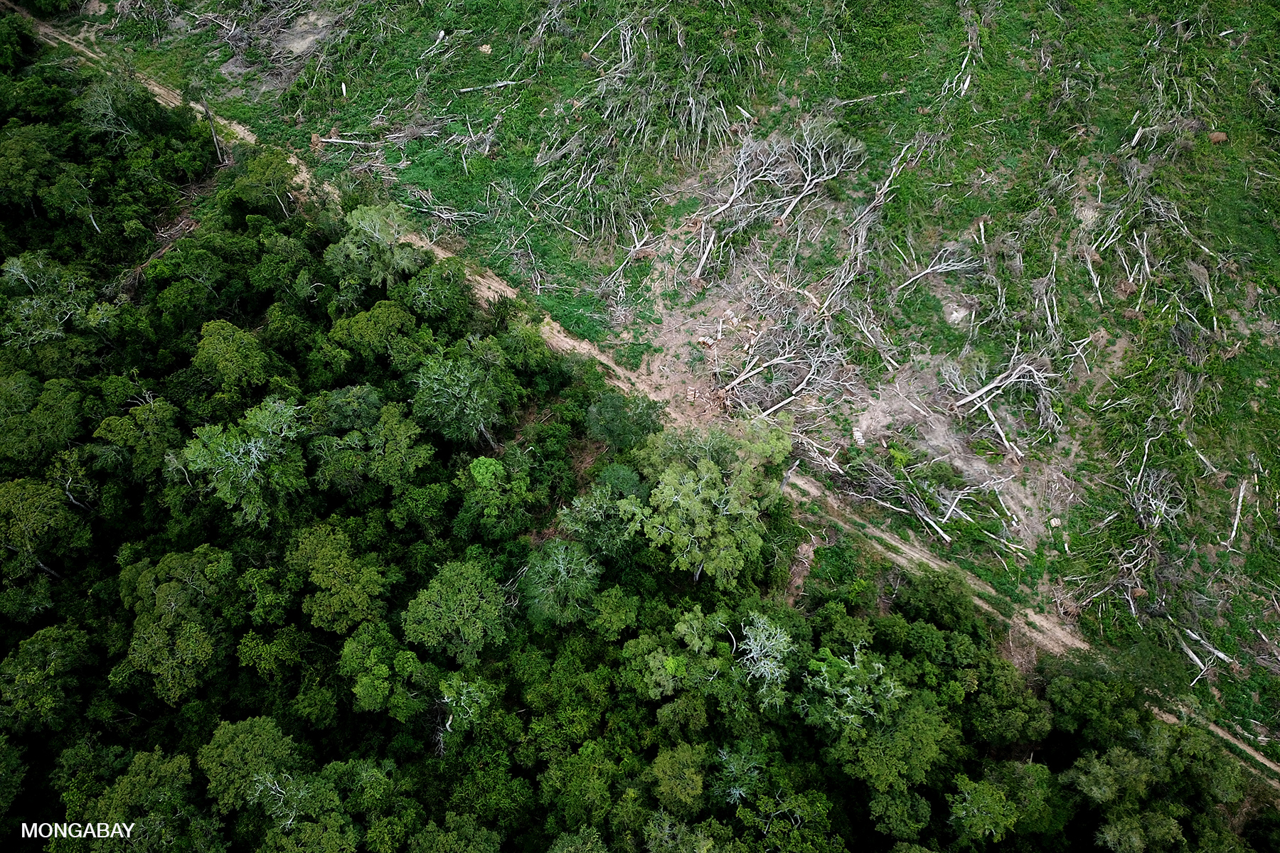
The result of this shift is forests in the Amazon
were cleared faster than ever before in the late 1970s through the mid
2000s. Vast areas of rainforest were felled for cattle pasture and soy
farms, drowned for dams, dug up for minerals, and bulldozed for towns
and colonization projects. At the same time, the proliferation of roads
opened previously inaccessible forests to settlement by poor farmers,
illegal logging, and land speculators.
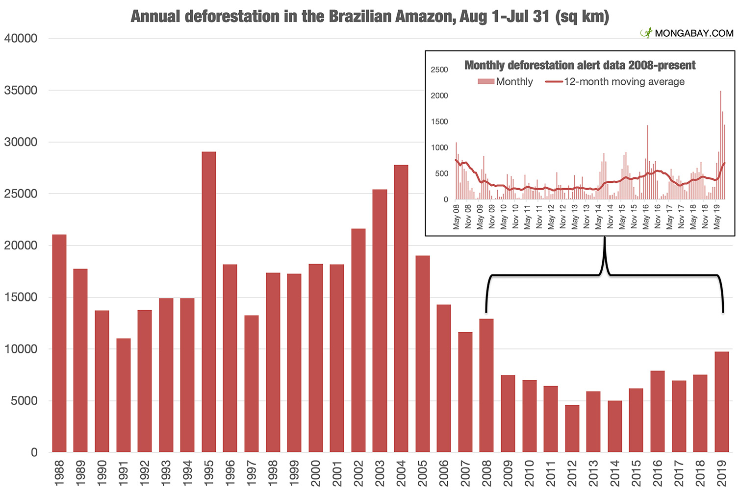
But that trend began to reverse in Brazil in 2004.
Since then, annual forest loss in the country that contains nearly
two-thirds of the Amazon's forest cover has declined by roughly eighty
percent. The drop has been fueled by a number of factors, including
increased law enforcement, satellite monitoring, pressure from
environmentalists, private and public sector initiatives, new protected
areas, and macroeconomic trends. Nonetheless the trend in Brazil is not
mirrored in other Amazon countries, some of which have experienced
rising deforestation since 2000.
However Brazil's success in curbing deforestation has
stalled since 2012. And in July 2019, deforestation soared to levels
not seen since the mid-2000s. [Amazon deforestation rises to 11 year high in Brazil (Nov 18, 2019)]
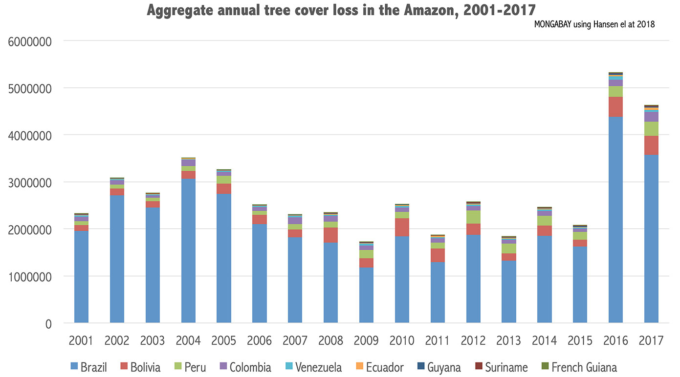


Deforestation trends in Amazon countries
Forest loss trends between Amazon countries are
highly variable. The following charts are based data from Matt Hansen
and colleagues, as presented in Global Forest Watch, using a "loose"
definition of the Amazon that extends beyond the Amazon river basin.
This includes the Guianas, all of Amazonas state in Venezuela, and all
of the states of Maranhão and Mato Grosso in Brazil. Forest is defined
as areas having more than 50 percent tree cover.
Please note: Amazon deforestation data is updated monthly here.
Brazil
Brazil [news]
holds about one-third of the world's remaining rainforests, including
more than 60 percent of the Amazon rainforest. Deforestation in the
Brazilian Amazon declined sharply in the mid-2000s due to government
interventions, macroeconomic factors, and efforts by civil society.
However in recent years, that decline has stalled, with deforestation
beginning to rise again.
The history of dramatic decline in the Brazilian Amazon's deforestation rate is detailed in our environmental profile on the country. For updates on deforestation in the Brazilian Amazon, check our Brazil deforestation news feed.

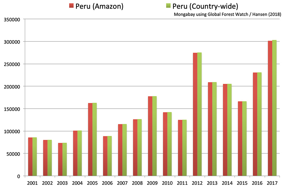
Peru
Peru's [news]
rate of forest loss has been trending upward over the past decade.
Reasons for the rise include the development and completion of the
Transoceanic highway, which connects Pacific ports to the heart of the
Amazon; a surge in gold mining in Madre de Dios and other regions along
the eastern slope of the Andes; and increased logging and hydrocarbon
extraction.
Colombia
The rate of forest loss in the Colombian Amazon [news] has been roughly flat since 2000.

Bolivia
Bolivia's [news]
deforestation spiked in 2008 and again in 2010. Overall the country's
rate of loss has been increasing at the second highest rate in the
Amazon.

Ecuador
Ecuador's [news]
rate of forest loss in the Amazon increased between 2001 and 2012. One
of the top concern for environmentalists is the government's decision to
open Yasuni National Park for oil drilling.

Venezuela
Only a part of Amazonas state in Venezuela [news]
is considered part of the Amazon rainforest, but for the purpose of
this estimate, the entire state is used. Most of Venezuela's rainforest
found in areas that are part of the Orinoco river basin. Forest loss in
the Venezuelan Amazon has been mostly flat since 2000.

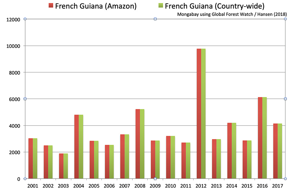
The Guianas
While Suriname [news], Guyana [news], and French Guiana [news]
aren't part of the Amazon River basin, their forests are often lumped
in as part of the Amazon rainforest. Forest loss in the three countries
has sharply increased in recent years.


Drivers of deforestation in the Amazon
Several trends are contributing to industrial conversion in the Amazon rainforest:
- Increased government incentives in the form of loans and infrastructure spending, including roads and dams;
- Scaled-up private sector finance due to growing interest in "emerging markets" and rising domestic wealth;
- Surging demand for commodities like beef, soy, sugar, and palm oil
Direct drivers of deforestation in Amazon countries
Cattle ranching
Cattle ranching is the leading cause of deforestation
in the Amazon rainforest. In Brazil, this has been the case since at
least the 1970s: government figures attributed 38 percent of
deforestation from 1966-1975 to large-scale cattle ranching. Today the
figure in Brazil is closer to 70 percent. Most of the beef is destined
for urban markets, whereas leather and other cattle products are
primarily for export markets.
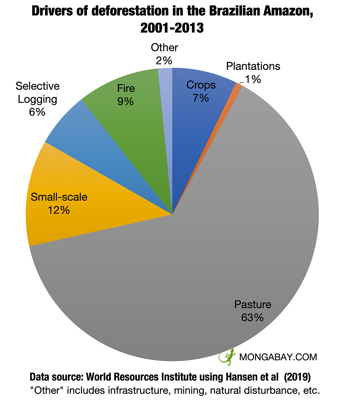
| Causes of deforestation in the Amazon, 2001-2013 | Share of direct deforestation |
|---|---|
| Cattle ranching | 63% |
| Small-scale agriculture Includes both subsistence and commercial | 12% |
| Fires Sub-canopy fires often result in degradation, not deforestation | 9% |
| Agriculture Large-scale industrial agriculture like soy and plantations | 8% |
| Logging Selective logging commonly results in degradation, not deforestation | 6% |
| Other Mining, urbanization, road construction, dams, etc. | 2% |
But production of beef, leather and other cattle
products isn't the only reason for converting rainforest into artificial
grasslands. In a region where land prices are appreciating quickly,
cattle ranching is used as a vehicle for land speculation, much of which
is illegal. Forestland has little value—but cleared pastureland can be
used to produce cattle or sold to large-scale farmers, including soy
planters.
However the situation — at least in the Brazilian
Amazon — may be starting to change. Since 2009 major cattle buyers and
the Brazilian government — pushed by environmental campaigners — have
cracked down on deforestation for cattle production. State-run banks are
now mandating landowners register their properties for environmental
compliance in order to gain access to low-interest loans. Meanwhile
major slaughterhouses have pledged stricter controls on their cattle
sourcing to ensure they aren't driving deforestation or the use of slave
labor on ranches.
Such trends have yet to emerge in Peru, Bolivia, and
Colombia, where cattle ranching remains a major driver of Amazon forest
loss.
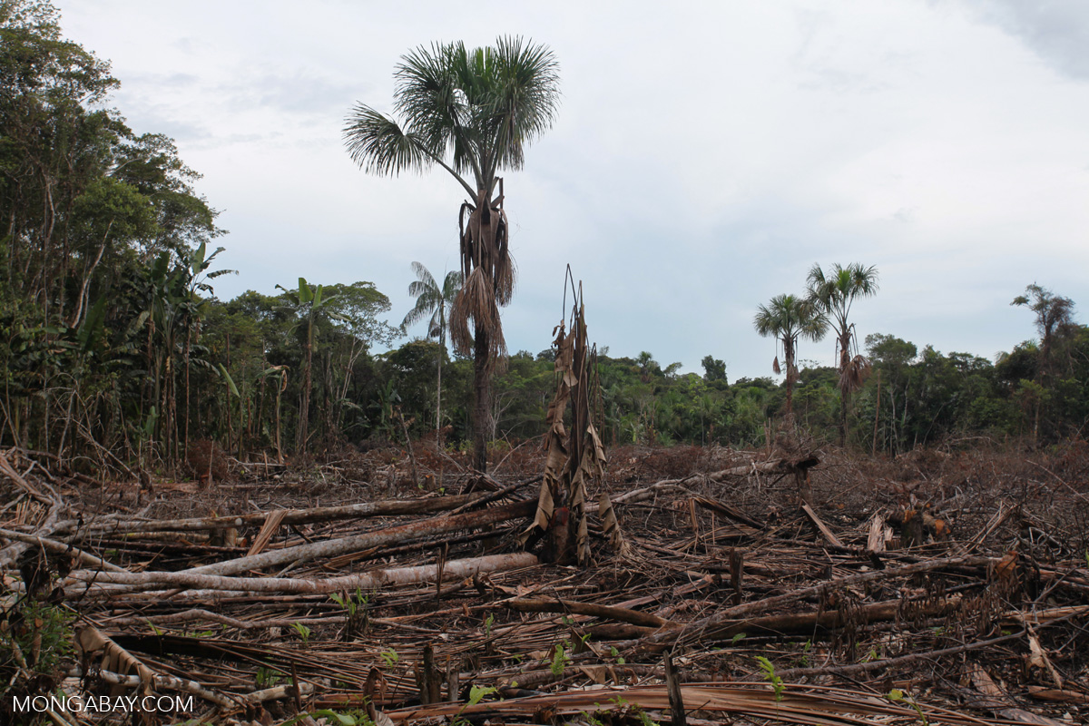
Colonization and subsequent subsistence agriculture
Historically, subsistence agriculture has been an
important cause of deforestation in the Amazon. Small-scale agriculture
has often been facilitated by government colonization programs aiming to
alleviate urban population pressure by redistributing or granting rural
land to the poor. In some cases these programs have failed to meet
their development goals while simultaneously unleashing an environmental
Armageddon.
For example in the 1970s, Brazil's military
dictatorship expanded its ambitious colonization program centered around
the construction of the 2,000-mile Trans-Amazonian Highway, which would
bisect the Amazon, opening rainforest lands to (1) settlement by poor
farmers from the crowded, drought-plagued north and (2) enabling the
exploitation of timber and mineral resources. Under the program,
colonists would be granted a 250-acre lot, six-months' salary, and easy
access to agricultural loans in exchange for settling along the highway
and converting the surrounding rainforest into agricultural land. The
plan would grow to cost Brazil US$65,000 (1980 dollars) to settle each
family.
The project was plagued from the start. The
sediments of the Amazon Basin rendered the highway unstable and subject
to inundation during heavy rains, blocking traffic and leaving crops to
rot. Harvest yields for poor farmers were dismal due to poor training
and inadequate soils, which were quickly exhausted necessitating more
forest clearing.. Logging was difficult due to the low density of
commercially exploitable trees. Rampant erosion, up to 40 tons of soil
per acre (100 tons/ha) occurred after clearing. Many colonists,
unfamiliar with banking and lured by easy credit, went deep into debt.
Adding to the debacle was the environmental cost of
the project. After the construction of the Trans-Amazonian Highway,
Brazilian deforestation accelerated to levels never before seen.
Commercial agriculture
After the commercialization of a new variety of
soybean developed by Brazilian scientists to flourish in rainforest
climate, soy emerged as one of the most important contributors to
deforestation in the Brazilian Amazon from the 1990s through the
mid-2000s.
Soy was both a direct and indirect deforestation.
While forest was converted directly for soy fields, the crop's impact on
rainforests was much larger, providing an impetus for new highways,
driving up land prices and thereby encouraging land speculation, and
encouraging ranchers and small farmers to move deeper into rainforest
areas.
But the situation in Brazil has changed significantly
since 2006, when a high profile campaign by Greenpeace forced Brazil's
largest soy producers to commit to avoiding deforestation for new
production. However deforestation for soy is still widespread in Bolivia
and Paraguay.
Meanwhile other forms of commercial agriculture,
including rice, corn, and sugar cane, also contribute to deforestation
in the Amazon, both directly through forest conversion and indirectly by
driving up land values.

Logging
In theory, logging in the Amazon is controlled by
strict licensing which allows timber to be harvested only in designated
areas, but in practice, illegal logging remains widespread in Brazil and
Peru.
Logging in the Amazon is closely linked with road
building. Studies by the Environmental Defense Fund show that areas that
have been selectively logged
are eight times more likely to be settled and cleared by shifting
cultivators than untouched rainforests because of access granted by
logging roads. Logging roads give colonists access to remote rainforest
areas.

Other causes of forest loss in the Amazon
Historically, hydroelectric projects have flooded
vast areas of Amazon rainforest. The Balbina dam flooded some 2,400
square kilometers (920 square miles) of rainforest when it was
completed. Today dams drive deforestation by powering industrial mining
and farming projects. Hundreds of dams are planned in the Amazon basin
over the next 20 years.
Mining has had a substantial impact in the Amazon.
High mineral and precious metal prices has spurred unprecedented
invasions of rainforest lands across Brazil, Venezuela, Colombia, French
Guiana, Suriname, Guyana, and Peru. A 2013 study found that the area
torn up for small-scale gold mining increased 400 percent in 13 years.
Oil and gas development is fueling environmental
concerns in the Western Amazon. Large blocks of rainforest have been
granted for exploration and exploitation licenses in recent years.

Deforestation monitoring in the Amazon rainforest
This section is excerpted for an story published on Mongabay News: What’s the current deforestation rate in the Amazon rainforest?
Nearly two-thirds of the Amazon rainforest is located
in Brazil, making it the biggest component in the region’s
deforestation rate. Helpfully, Brazil also has the best systems for
tracking deforestation, with the government and Imazon, a national civil
society organization, releasing updates on a quarterly and monthly
basis using MODIS satellite data, respectively. Both the Brazilian
government and Imazon release more accurate data on an annual basis
using higher resolution Landsat satellite imagery.
For other Amazon countries — primarily Colombia,
Ecuador, Peru, and Bolivia since Venezuela, Suriname, Guyana and French
Guiana are mostly outside the true Amazon basin watershed — the most
reliable source for regular updates is Global Forest Watch, a platform
that aggregates data from a many different sources. Currently Global
Forest Watch has FORMA, a near-real-time forest cover monitoring system
that also uses MODIS, and annual estimate made by a group of researchers
led by a team at the University of Maryland.
Variance in monthly deforestation
Month-to-month deforestation is highly variable
leading to frequent misreporting in the media. Both MODIS and Landsat
cannot penetrate cloud cover, so during the rainy season — from roughly
November to April — estimates are notoriously unreliable when compared
to the same month a year earlier. Furthermore, most forest clearing in
the Amazon occurs when it is dry. So if the dry season is early,
deforestation may increase earlier than normal. For these reasons, the
most accurate deforestation comparisons are made year-on-year. For
Brazil, the deforestation “year” ends July 31: the peak of the dry
season when the largest extent of forest is typically visible via
satellite.
Nonetheless, short-term MODIS data isn’t useless — it
can provide insights on trends, especially over longer periods of time.
Generally, comparing 12 consecutive months of MODIS data will provide a
pretty good indication of deforestation relative to other years.
Therefore the charts below include a history of MODIS-based data as well
as the longer-term Landsat-based data. The MODIS system used by
Brazil’s National Institute for Space Research (INPE) is called DETER,
while Imazon’s system is called SAD. INPE’s annual Landsat-based system
is called PRODES.
Current monthly deforestation data for the Brazilian Amazon
INPE and DETER are used primary for law enforcement
since detection occurs on roughly a biweekly basis, enabling
environmental police to take action as large-scale forest clearing
occurs. The Brazilian government has cited “law enforcement” as the
reason it has switched to quarterly public releases of data, asserting
that more frequent releases could undermine the effectiveness of taking
action against illegal tree-felling.


Comments
Post a Comment
Feel Free and open to share your thoughts